


Excerpted from Neil’s book LandBook – An owner’s manual for rural land (second edition)
~~~~~~~~
Since this book is about land, the use and management thereof, you’ll find it a lot more fun if you can play along by owning some land yourself, so that’s what I’ve dedicated this chapter to: you being able to buy some land, even if you don’t happen to be obscenely rich. (If you have disgustingly vast sums of cash, you may wish to skip to the next chapter.)
It seems as if everybody wants some land, and those that already have it want more. I suppose there are a few exceptions to this rule, but not many, because even a monk needs a monastery. That’s why land prices are always high, and why some folks feel that if they can’t afford to buy land now, they’ll never be able to in the future.
Perhaps that’s why tax sales and foreclosure auctions are so popular: they embody the lure of getting something extremely valuable for a price we can actually afford. Alas, tax sales may be a dandy way for the state to collect its due, but the buyer frequently does not end up with marketable title, and in similar ways, foreclosure auctions may prove to be far more trouble than they’re worth. Both methods are even more complicated than they look, and while bargains do exist, so do many pitfalls which await the uninitiated who haven’t done due diligence. There’s also the fact that you have no control over the location and type of property that becomes available for distress sales.
After a time, we may get the idea that, if we only have a limited amount of money to spend, we need to accept land which is deficient in some way: property adjacent to a landfill perhaps, or without deeded access, or with some other aspect that we wouldn’t consider desirable if we had other choices. We feel that we must pay some other cost in lieu of the cash we don’t have to spend, in order to get an affordable deal.

Or at least that’s what a lot of people think; it’s the Hair Shirt Theory, but it’s far from true. In fact, the best way to save hot, steaming piles of cash on a land purchase is simply to find someone whose plans have changed because, even in this day and age, unwanted land still exists for those who know how to find it.
Here’s an example: Arlene met Bob at Woodstock. Together they planned to leave New Haven as soon as Arlene finished her degree in anthropology. They had a dream, to move out into the country and let their lives regress to the Stone Age. They’d live nude except for animal skins, and make their living foraging for roots and berries. After a few years, they’d write a book and become famous. So, with some money from her inheritance, they bought forty acres of wooded land in the Midwest with a really charming cave, and began to fashion their future.
However, it turned out that Bob had uncouth personal habits, and Arlene was quite a bit of a nag. Thus, it came to be that Arlene and Bob gradually grew apart, and went their separate ways.
That was years ago, but Arlene still has that property. She hardly ever thinks about it though, except when the annual tax bills come in. Even then, the taxes on vacant woods seem so cheap compared to her Atlanta condominium that she just pays them without much thought. The price she and what’s-his-name paid for the land back then wouldn’t buy her a space in the parking lot today, so she doesn’t view it as much of an asset.
I suppose you could say that Arlene’s lust for land has been fairly sated by this time.
So you’re thinking, “That’s a great story, Neil, and if I had the rest of the morning to waste, I’d sure like to hear the whole thing, but since I don’t, and since I don’t know anybody like you’re describing in the area where I want to buy land…”
Bear with me a moment.
You can find people like Arlene everywhere. It’s simple. But first, you’ll need a couple of tools.
Tools You’ll Need for Buying Land Very Cheaply
Tool Number One: A County Ownership Plat Book: Each county in every state makes their real estate ownership data available to private mapping companies who make maps detailing all the land ownership in the county. You can usually find these for sale in one or more of the offices in the county courthouse. They tend to run $25-80. These days the data may be available online, so check out that possibility before you buy anything.
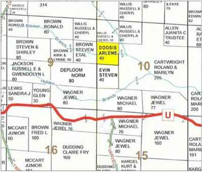
BELOW: Here’s a page from the appropriate county plat book showing the 40 acres belonging to Arlene Doosis.
Tool Number Two: Maps: It would be a nice idea if you have plenty of maps of your area. I used to buy these on paper, and I have a large collection of them molding away in the basement, but now I find that I can get everything I need online, and for free. As time goes by, my paper maps are growing outdated and while I still appreciate them for their aesthetic beauty—when applicable—their utilitarian value is diminished, although there are times when old maps can still offer insights into modern-day properties, as we’ll see later in this chapter.
Let’s take a moment to discuss a few types of maps that are particularly useful – and their limitations.
County Highway Maps: Most states offer county maps on the internet which have been prepared by their respective Departments of Transportation. Their primary benefit for our purpose is that, in addition to roads, towns and cities, many of them, particularly those from the more rural states, show the Public Land Survey System (PLSS) grid, so they make a nice place to start your search for any given property. If you have a legal description, but no ownership plat, see if you can find one of these to work with.
U.S.G.S. 7.5-minute Topography Maps: Accurate, beautiful and universally available, the paper versions of these maps have been the basic tool of the real estate industry throughout the last half of the 20th Century, and the Adobe .pdf versions you’ll find at https://store.usgs.gov/ remain so today. Unfortunately, I must qualify that statement: the accuracy of the paper maps was unparalleled, their only failing being that they were only updated infrequently. Most of the online versions currently available have been updated using automation that apparently makes wild, and very frequently incorrect, guesses. You can still have confidence in the contour lines, as those rely on the old data, but many of the updated roads are actually private driveways, abandoned trails, or simply some misguided computer’s fever dreams. You may find several versions of the map you choose, some dating back to the 50’s or earlier, but in the digital form, you’ll probably want to get the most recent (2015 and beyond) versions because a Public Land Survey System overlay has been added.
Google Earth®: This is the answer to a dream we didn’t even know we had. Google Earth is aerial photography of the entire globe that allows you to zoom in and out and fly from one place to another. This is not to be confused with Google Maps®, Bing Maps® or Yahoo Maps®, all of which are nearly useless for our purposes here. You can use GE to measure property with amazing accuracy, and then define boundaries with a drawing tool. You can work with a flat image showing land as viewed from straight overhead, or tilt the screen for a very realistic view of the terrain. Furthermore, it allows you to travel in time to see what a given property looked like in the past, going back to around 1995. GE is updated about every three years in most locations, and the resolution improves with successive generations.
Throughout this chapter, I’ve placed different views of Arlene Doosis’ 40-acre parcel on several different maps, to give you an idea of how much you can learn about a particular property without ever leaving home.
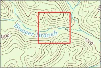
BELOW: This topography map tells us that the Doosis 40 has an elevation range of about 140 feet from the high point on the northern boundary to the intermittent stream on the east side. However, it shows no sign of any access road. Contour intervals are at 20 feet of elevation here, however, 10-foot intervals are used on some maps, so be aware by checking the map legend.
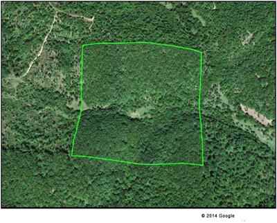
BELOW: This time at least, the latest Google imagery isn’t much help. We see that there’s a road not far away, but no indication of how to access the property.
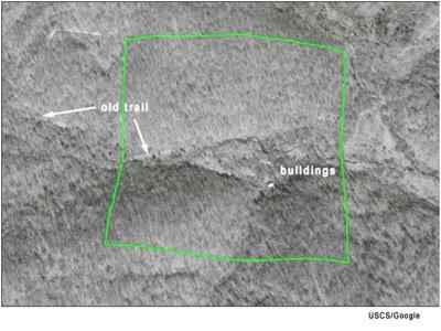
BELOW: This aerial view from 1995 sheds more light on the situation, literally, as the leafless trees allow us to see what appears to be an old trail coming in from the west. That’s not to say that there’s a legal easement, but it’s a nice start. Plus we see a couple of what appear to be abandoned buildings that may hint at an old well or other improvements.
Tool Number Three: The County Assessor’s Office:
The last tool you need comes to you free with your real estate taxes. It’s the County Assessor’s Office, which keeps track of who owns what land in the county in order to assess property taxes.
That means that you can find the names of the owners of the blocks of land shown in your plat book there, as well as their addresses.
Oh, something I should probably have mentioned sooner: this method of Buying Land Very Cheaply is sure-fire and proven, but it does have a couple of drawbacks.
Drawback Number One: There’s work involved.
Drawback Number Two: You’ll still need some money to buy land. That’s why this method works. All those other methods that don’t include you having money don’t work—a big difference.
What you want from the County Assessor’s Office are the names and address of all landowners in your area of interest who have out-of-area addresses; the further out-of-area the better.
Arrive at the assessor’s office with a friendly smile, tell the clerk that you’d like to copy some addresses for property owners in Sections X and Y, and ask if she could show you to the appropriate book(s). (Later, you can ask for Sections Z and A if you don’t get enough names. I don’t recommend that you go in sounding as if you’re going to be there all day.)
I also suggest you try to define your area to four or five mile-square sections. Using your topography map, pick the sections you’re interested in, write down the number, township and range, and take that information to the assessor’s office. (See Chapter 13: How to Read Legal Descriptions.)
Once you have the names and addresses of each out-of-area owner of vacant land in the area where you want to buy land, go back to your maps, and see how many of the properties appear to meet your broad criteria.
If your land needs are very specific, then you’re going to be doing more work than if they’re fairly general. For example, if you just have to have frontage on a stream, then you’ll want to concentrate on locating streams as they cross properties in the plat book. You’ll be able to eliminate several of your choices using the maps, but when you get down to the most serious candidates, you’ll want to go visit the properties in person.
When you do, be sure to take a topography map and compass with you, and be careful to avoid trespassing on neighboring properties, whose owners may be more close at hand than the owners of the properties you’re looking at.
Once you’ve gathered your addresses and very thoroughly examined all the candidate properties, it’s time to go back home and write a few letters.
To each of the out-of-area owners you’ve selected, you send a letter something like this:
Arlene Doosis
232433 Swansong Street, Apt 98
Atlanta GA 20144
Dear Ms. Doosis:
I am writing to inquire about your 40-acre property in Polecat County. I am in the market for a property such as this, and I would be willing to pay $[give your specific offer] for your land, should you be interested in selling. If you would consider selling this land, please contact me at the address below.
Sincerely,
You
Note that we don’t dwell on formalities here. It’s important that you make the deal very straightforward.
Perhaps now you see the tricky part. You have to be sure enough of yourself and what you’re willing to pay to put your offer right up front.
I recommend that you send out as many as a couple of dozen of these letters, perhaps in groups of five or six.
When you start mailing them out and your replies start coming in, you will mostly get any of three sorts of responses: they’ll either ignore your letter completely, accept your terms, or inform you emphatically that the property is worth much more than whatever you said you’d give, which you may treat as an offer to negotiate.
So are we taking advantage of someone here? Not at all.
Let’s take a moment to talk about the concept of what land is worth:
Nobody knows.
That is, there is the profession of appraising real estate, and while that may be a noble and scientific profession, when they assign a price to a particular parcel, that does not mean that they will give the owner that much money for the land in question, only that similar sales in the area (if any) have suggested what the price might be.
In our exercise here, you are putting yourself in the position of a much more authoritative appraiser because you’re backing up your appraisal with cash.
Cash has a lot of appeal to Arlene. Even though her land has value, if she wants to sell it, she needs either to list it with a real estate agent, or make the effort to sell it herself.
The majority of real estate agents prefer spending their time promoting larger, improved properties, which offer several times the commission, and probably for a lot less effort than marketing Arlene’s remote forest. In a not-particularly-stellar market, her property could wait years for a buyer.
If she has the wherewithal to advertise it herself, she’ll need either computer savvy, or money—both would be best—and a certain amount of time to devote to the effort.
If you send a letter such as the one described to a dozen people in the typical, desperate-as-usual economy, at the very least one or more of them is likely to be going through some sort of personal crisis, and would much prefer to have some cash than a piece of land that sits unwanted and unloved, in a distant state. I will all but guarantee you that you will be doing something to help out another person in a very real way.
I once bought a piece of land from a dear old woman who just wanted the money to help her granddaughter with college tuition. She told me that the bus driver she’d talked to on her trip to the closing said, “I’ll bet your land’s worth a lot more than he’s giving you” and she said, ‘I’ll take that bet, because I’ve owned it for thirty years and no one’s ever offered to give me anything for it.'”
There is no limit as to how low your offer can be, but it should be within reason, or it’s likely to be rejected out of hand. The landowner only has to log on to the internet to compare your offer with what brokers are selling land for, so you can’t be senselessly low, but since you’re offering cash right now, a good many people will be willing to sell for significantly less in order to have a deal right now that doesn’t include paying any commissions.
You can determine what is within reason to your own mind by simply perusing similar property on your state’s Multi-list sites. Read forty want-ads and visit five or six of the properties, and you’ll have about as good an idea of what that sort of land is worth as anyone else.
There’s something else nice to know when you’re thinking about how much to offer: many times the landowner’s deed will specifically state how much he or she paid for the property. Knowing how much they stand to make (or lose) can help you in making your decision of how much you want to pay.
You can find a copy of the deed at the County Recorder’s Office. If that doesn’t state the sale price, you may find an old mortgage on record that would give you some idea of the former price. Also, in some jurisdictions, what’s known as “revenue stamps” are affixed to deeds in proportion to the sale price. Each stamp represents a certain valuation, so if you learn the tax rate from the County Collector or Recorder, you can determine the selling price of the property.
When you find a buyer who agrees to your price, you need to take charge of closing the transaction. You don’t need an attorney here; just find a title company in the county seat. They’ll examine the title for you, distribute the costs, and close the sale.
If you’re going to give this method a try, I wish you good luck. I’ve purchased many parcels of land this way, and have without exception been given to understand that I was helping each of the sellers significantly, while at the same time getting a very good deal for myself. There is little more that one can hope for in a transaction than when both sides walk away happy.

Throwing in the Towel: How to Move to the Country Fast and Cheap
I suppose there are a few exceptions to this rule, but not many, because even a monk needs a monastery.
if you google “_____ County, State GIS” you will find that most of the tax records have been placed online, and you can search the GIS “Go Map” for tax records. This makes it easier to out who owns that vacant/distressed property you might have your eyes on.
It was helpful when you mentioned that we can use Google Earth to better view the terrain and measure property boundaries accurately. My husband and I want to buy some acreage of land within the next month or so so we can start building a custom vacation home. Your article provided some great resources we can use to evaluate potential plots of land, so thanks for sharing!
As you mentioned, it is a good idea to have a map of the area in which you are looking to buy land. In doing this, you can see who owns property near where you want to buy, and if there are any plans to build roads near the land. My brother wants to buy some rural property, I will have to share this list with him, and see what he thinks.
I love how this method works! Buying cheap lands and know how to protect them is very important. Technology is really a great help to us.
That’s a good idea to use county highway maps to view the public land survey grid. My husband and I would love to start a homestead and small lobby farm, so we want our next home to have some extra acreage with it. I will keep your tips in mind as we shop for the perfect plot of land.
This is Test
Thanks your shared! I hope you will continue to have similar posts to share with everyone! I believe a lot of people will be surprised to read this article!
Anyone know how this all could be applied for Canadians? I’m looking to buy land in BC Canada.
Thank you for this informative article, Neil! As someone who dreams of one day owning a piece of land to build a sustainable homestead, I found your tips on how to find affordable land very valuable. I appreciated your advice on looking beyond the traditional real estate market and exploring other avenues, such as tax sales and government auctions. Keep up the great work!